

Paul Ligeti
In this article, we explore one of West Windsor’s historic neighborhoods. Although it effectively disappeared decades ago, it remains well documented and well remembered by many longtime residents.
Colonial Roots
Today, thousands of motorists pass near the intersection of Route 1 and Quakerbridge Road without realizing they are traveling through what was once a historic rural crossroads. This community, overlapping West Windsor and Lawrence townships, also included the surrounding landscape.
It was named after the Clarke family, who settled in present-day Princeton following Benjamin Clarke’s purchase of more than 1,200 acres of land in 1696, overlapping present-day West Windsor and Princeton. Although the hamlet’s name, dating at least as far back as the 1820s, if not earlier, was originally spelled “Clarkesville,” the “e” was dropped at an unknown date.
It is currently unknown exactly when pioneers first settled the “West Windsor” part of the 1696 purchase, as opposed to the “Princeton” part. However, we do know that farming families lived here at least by the 1770s, if not significantly earlier.
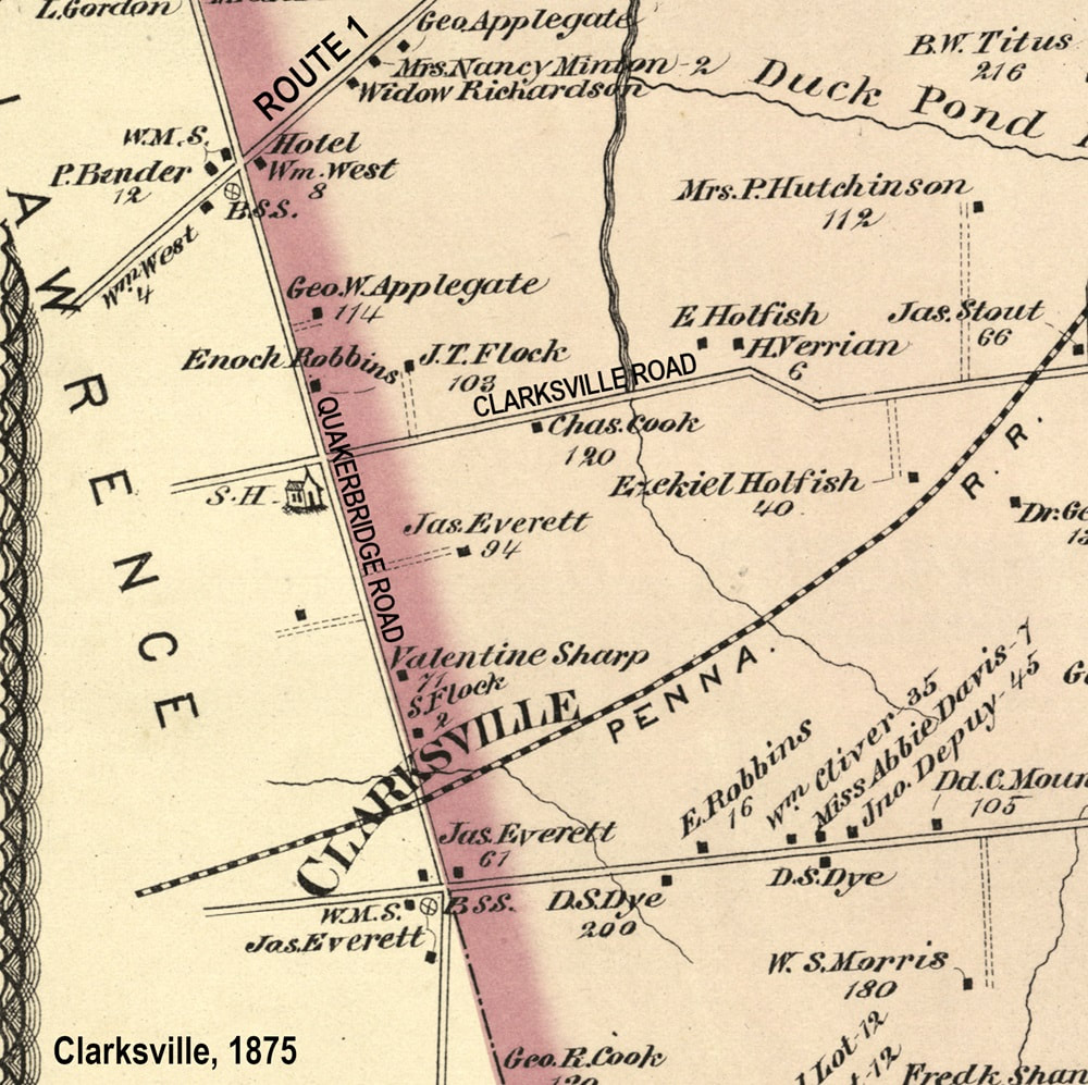
British troops were captured on Dec. 30, 1776, during the American Revolution at a local farm, where the “J. T. Flock” farm is shown on the adjacent 1875 map, about one-quarter of a mile northeast of the intersection of Clarksville and Quakerbridge roads. These soldiers divulged crucial information about British troop movements to George Washington’s army that helped him triumph at the Second Battle of Trenton and Battle of Princeton during the war’s darkest hours.
Only four days later, nearby residents witnessed the American army marching from Trenton, up Quakerbridge Road and on its way to victory at the Battle of Princeton.
Enterprises
We can pinpoint a particularly influential individual in early 1800s Clarksville: Dr. Israel Clarke, who served as West Windsor’s town physician for years, enslaved at least several people locally and may be the specific person after whom Clarksville was named.
He owned an inn called “Windsor Hall” at the crossroads of Route 1 and Quakerbridge Road in the early 1800s. This building was eventually acquired by William West Jr. in 1864. Again, see the adjacent 1875 map.
West hosted most West Windsor meetings from the 1870s through the 1890s before the township moved back to the community of Dutch Neck in 1891. His hotel was one of a few licensed to serve liquor, undoubtedly a draw for many.
This same building was a speakeasy during Prohibition and was consequently the subject of prosecution. It seems to have been demolished to make way for Route 1 improvements in the early 1930s.
In the 1800s, Clarksville flourished as a farming community that profited from Route 1’s stagecoach travel. Throughout the century, it also featured a second inn, blacksmith, wheelwright, store and, of course, several farmsteads.
A schoolhouse, reputedly erected circa 1822, initially served 40 students under the tutelage of David Dye. It stood just inside Lawrence Township, at the southern corner of the intersection of Clarksville and Quakerbridge roads.
It was also used as a Sunday school, meeting house and festival site. The building reputedly burned in 1937.
Also near the intersection were two other public roadside establishments: the Clarksville Motel and the 1940s-era “Clarksville Diner.” The latter establishment is easily West Windsor’s best-traveled building.
Originally called the “Princeton Grill” and located at the Penns Neck traffic circle at Washington Road and Route 1, it was a popular 1930s-era eatery that was relocated to Clarksville in 1951.
In 1988, the diner was purchased by Gordon Tindall III, who relocated it to Iowa and restored it. Ten years later, for reasons yet unknown, it was purchased by the Canal+ media company based in Paris, France.
It was shipped across the Atlantic and converted into a studio. It still sits there overlooking the Seine, its prominent lettering alluding to its original hometown across the ocean.
Throughout the 1900s, Clarksville remained a farming community, home to several longtime families, including, but not limited to, the Colemans, Dilatushes, Dohertys, Reeds and Schencks.
One of the town’s largest tracts of farmland still existed here as of January 2024, on the northeast side of Quakerbridge Road.
American Cyanamid
Starting in the 1950s, American Cyanamid, an industrial chemical conglomerate, opened an agricultural research and development facility on the site of several old farms.
One of these was the farm where, as mentioned earlier, British troops were captured on Dec. 30, 1776, during the “Ten Crucial Days” of the American Revolution.
The company acquired the surrounding properties over the next few years, demolishing the old farmhouses in the process, including that very farmhouse and its barns.
However, the agricultural land was largely preserved as part of the R&D facility, and it was not uncommon to see pigs nearly the size of cows. The facility closed in the early 2000s.
Overdevelopment
In the ensuing years, the property passed through several owners, some of whom presented development plans that many township residents vehemently opposed.
These included a shopping complex proposed in 2006 by General Growth Properties and a massive mixed-use development with 2,000 housing units proposed by developer Howard Hughes.
The latter proposal, opposed by many residents because of concerns about impacts on traffic, infrastructure, schools, emergency services and other areas, resulted in a protracted lawsuit between Howard Hughes and the township.
In 2019, developer Atlantic Realty purchased the roughly 650-acre site, ending the lawsuit after a deal with the township allowed the company to propose a complex of massive warehouses spanning much of the property.
The proposal again elicited community concerns, especially about traffic and the environment. At the time of this writing on July 9, 2026, it remains pending.
Today, little remains of historic Clarksville. The widening of Route 1, commercial development and American Cyanamid’s acquisition of surrounding farms erased much of the old community.
One likely survivor is the Weber’s Kennels building at 3440 Brunswick Pike, Route 1, which tax records suggest may date to around 1800. Standing alone along Route 1, it serves as a quiet reminder of a community that has otherwise vanished.
The Historical Society of West Windsor is an all-volunteer community nonprofit. Every one of us donates our free time, without pay, to document and promote our township’s shared heritage.
But we need community support to keep this up. Please consider volunteering or donating. Visit westwindsorhistory.com.
Paul Ligeti is the president of the Historical Society of West Windsor.

